A physical orientation to Czechia: Central European position, relief, river systems, historical lands, settlement logic and the geographic structure behind the Atlas.
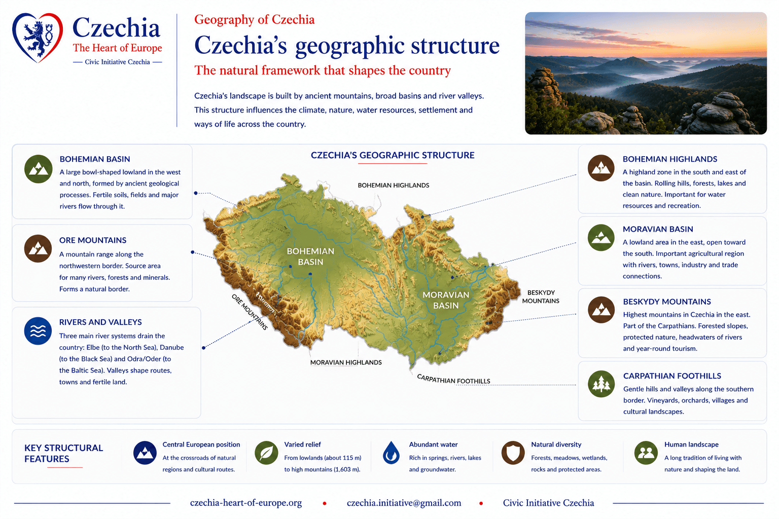
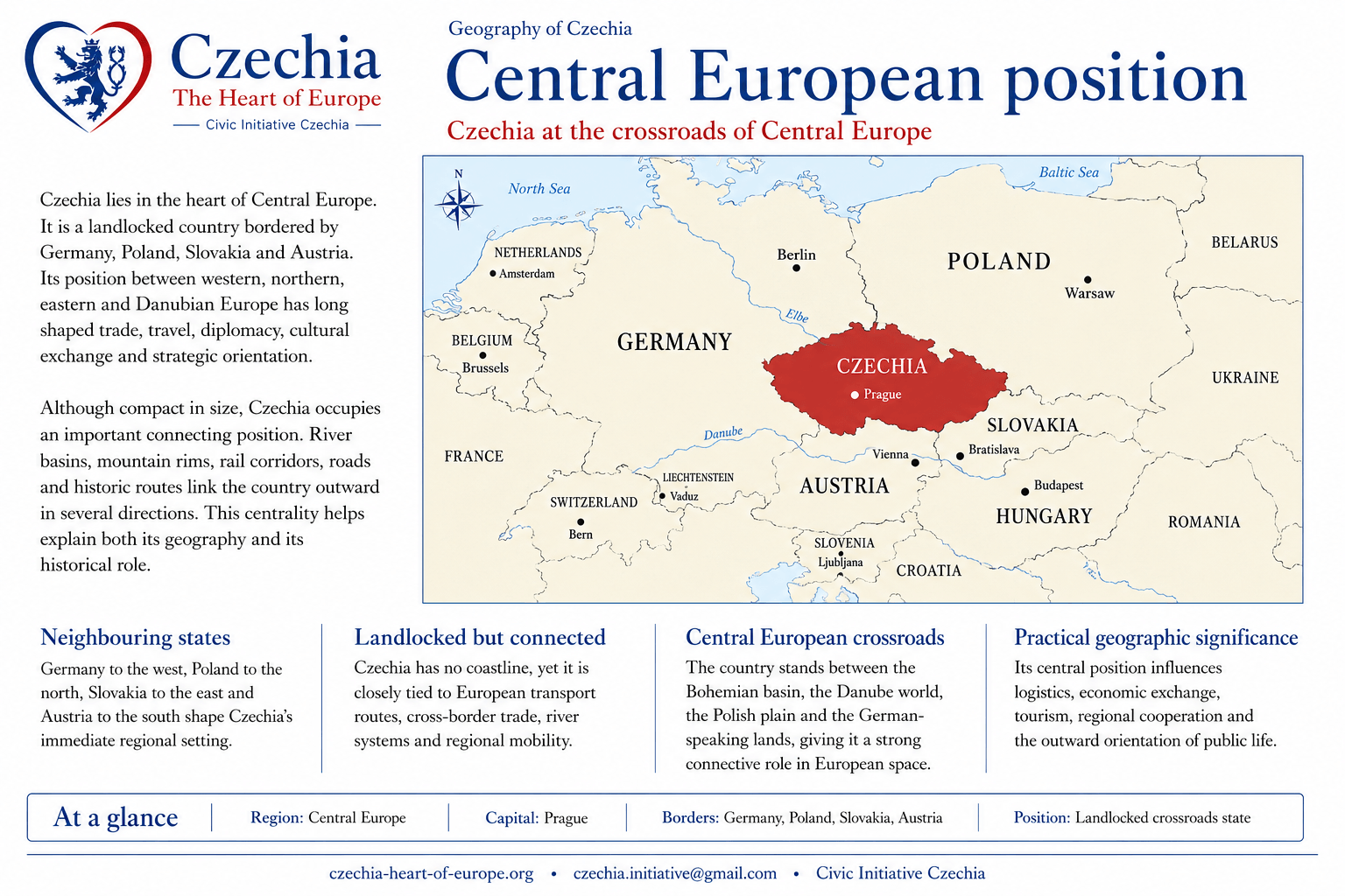
Czechia is a compact inland country in Central Europe, bordered by Germany, Poland, Slovakia and Austria. Its territory belongs mainly to the Bohemian Massif, with the eastern part reaching the western edge of the Carpathian system.
The country’s physical structure is organised by several complementary frames: the enclosed Bohemian basin and its mountain rim, the Moravian corridors and lowlands opening toward the Danube area, and the northeastern Silesian borderlands connected with the Odra/Oder basin. These structures influence settlement, transport, agriculture, industry, climate variation, water systems and regional identity.
PositionCentral Europe; bordered by Germany, Poland, Slovakia and Austria.
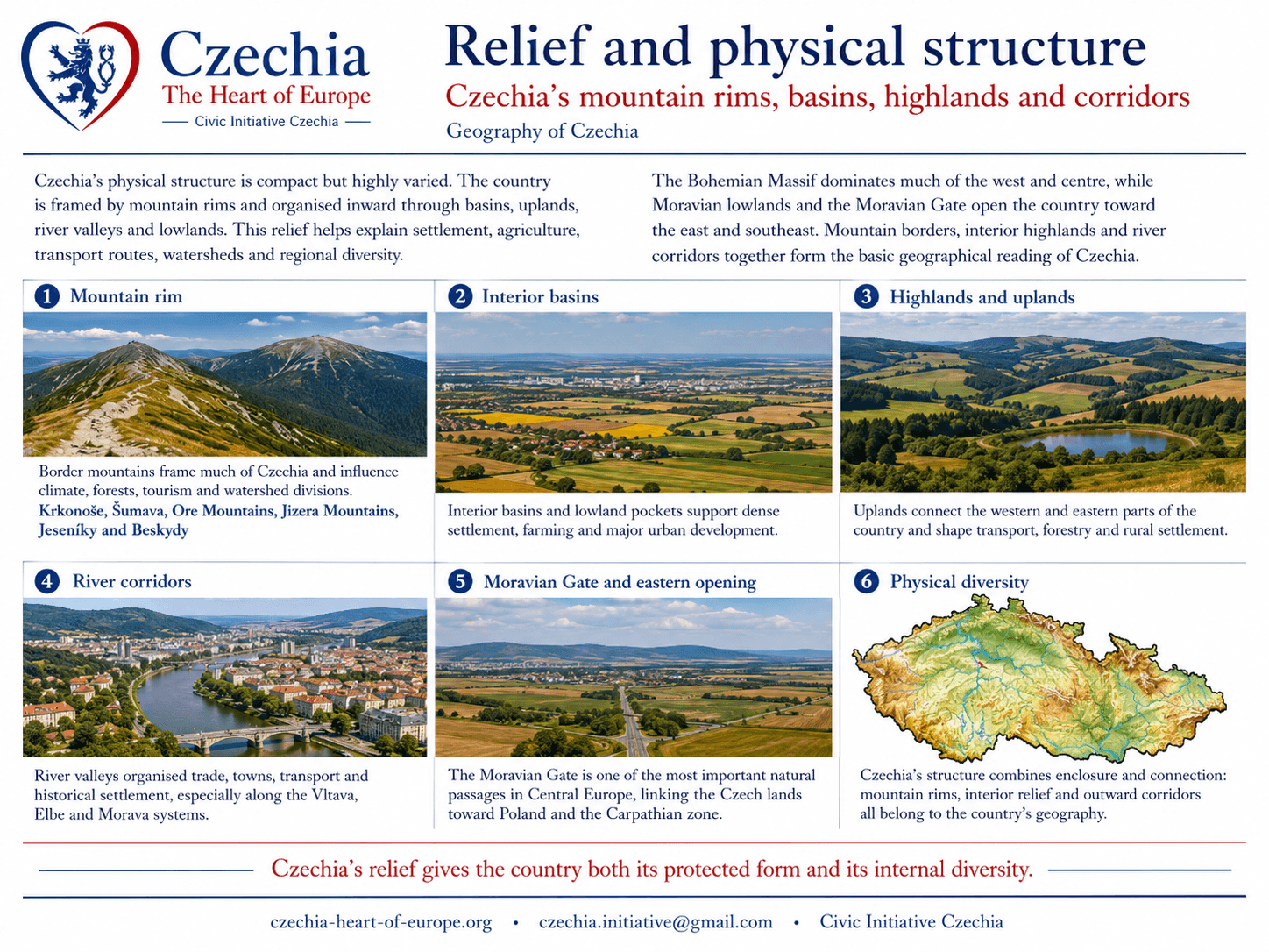
ReliefBohemian Massif, Carpathian edge, basins, highlands, mountain rims and river valleys.
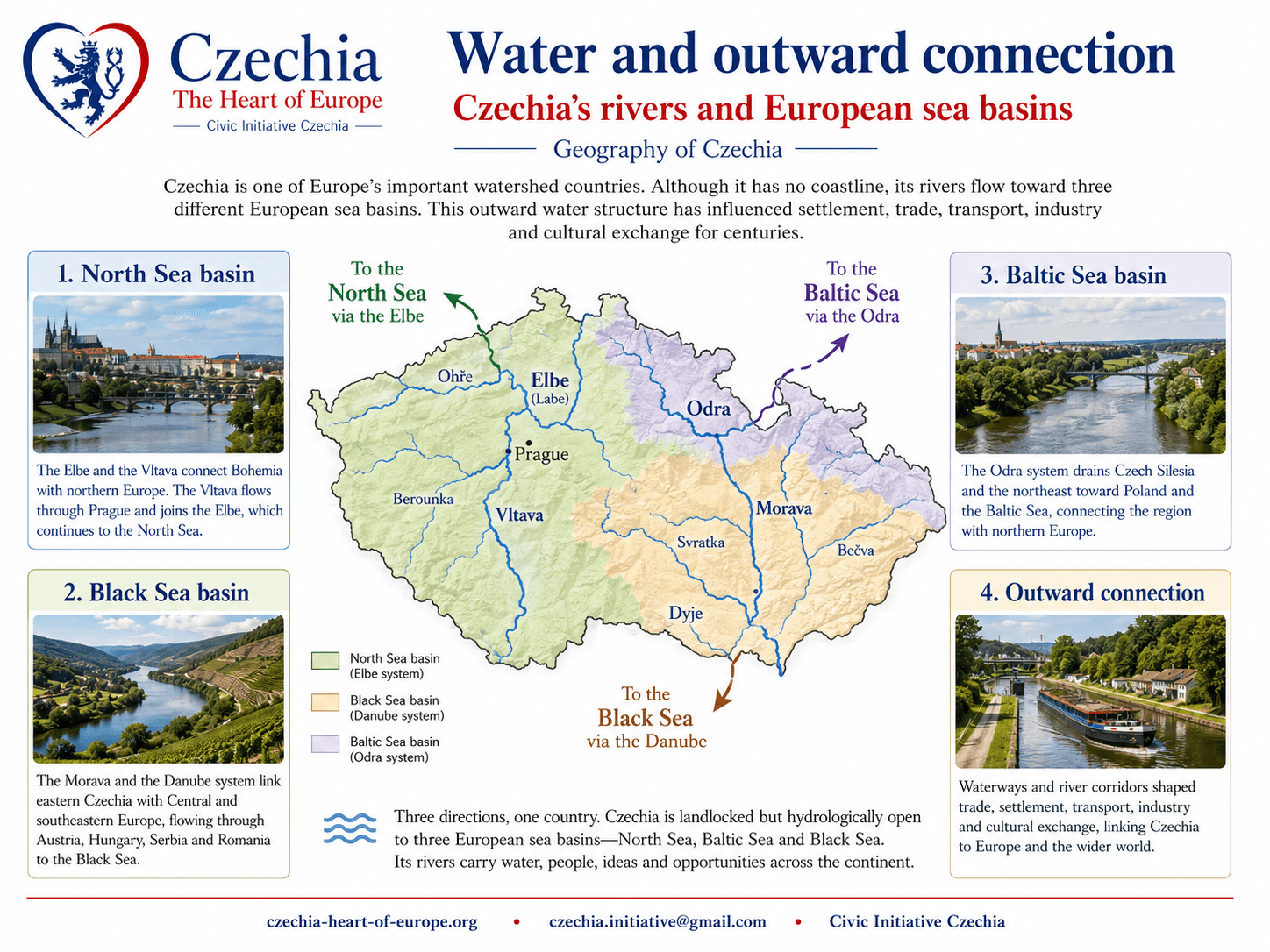
WatershedsRiver systems drain toward the North Sea, Baltic Sea and Black Sea basins.
Area78,871 km².
Highest pointSněžka in the Krkonoše Mountains.
Main river systemsVltava–Elbe, Morava–Danube and Odra/Oder.
Historical geographic framesBohemia, Moravia and Czech Silesia.
This page gives the general physical structure of Czechia. It does not replace the specialised Atlas pages. Climate, historical lands, regions, landscapes and watersheds each have their own role in the site structure.
Czechia occupies an inland position in Central Europe. Its borders connect it to the German-speaking west and south, the Polish and Silesian north, the Slovak and Carpathian east, and the wider Danube-facing space through Moravia and Austria.
This position matters geographically because Czechia is a country of contact zones: mountain borders, railway corridors, river basins, old trade directions, industrial regions, university cities, cross-border commuting areas and cultural transitions.
GermanyWestern and northwestern neighbour; strong economic, transport and borderland connections.
PolandNorthern and northeastern neighbour; mountain, Silesian and cross-border contact zones.
SlovakiaEastern neighbour; Carpathian contact, shared modern history and close cultural proximity.
AustriaSouthern neighbour; Moravian, Bohemian and Danube-facing Central European links.
The Bohemian Massif forms the dominant physical structure of the country. It gives Bohemia much of its basin-like form, surrounded by mountain and upland systems. Eastern Moravia and Czech Silesia connect to the Carpathian edge, producing a different spatial logic of corridors, passes, foothills and borderlands.
Relief affects more than scenery. It shapes where rivers flow, where towns developed, where transport corridors could pass, where agriculture is concentrated, where forests dominate, and where borders historically became durable.
Bohemian MassifThe dominant physical foundation of Bohemia and western Czechia.
Carpathian edgeEastern mountain and foothill systems connected with Moravia and Czech Silesia.
Basins and corridorsLowlands and river valleys concentrate settlement, transport and agriculture.
Mountain rimsBorder mountains influence climate, water sources, tourism and regional identity.
Bohemia, Moravia and Czech Silesia are historical lands, but they also help explain Czechia’s spatial structure. Each corresponds to a different geographic logic: Bohemia as basin and mountain rim, Moravia as river corridor and Danube-facing land, Czech Silesia as northeastern Silesian borderland and Odra/Oder contact zone.
These lands are not the same as today’s administrative regions. They give the Atlas its deeper territorial reading, while the modern regions explain current public administration and practical orientation.
BohemiaWestern and central Czechia; Bohemian Massif, Vltava–Elbe system, Prague and border mountains.
MoraviaEastern Czechia; Morava River, fertile lowlands, vineyards, karst and Carpathian edges.
Modern regionsFourteen regions provide contemporary administrative and public-service structure.
Water and outward connection
Czechia has no coastline, but water connects it outward. Its river systems drain toward three European sea basins: the North Sea through the Vltava–Elbe system, the Black Sea through the Morava–Danube system, and the Baltic Sea through the Odra/Oder system.
This makes water one of the strongest geographic keys to the country. Rivers organise settlement, historic trade, industrial corridors, flood memory, landscape identity and cross-border orientation.
Vltava–ElbeBohemian river system flowing north toward Germany and the North Sea.
Morava–DanubeMoravian river system opening toward Austria, Slovakia and the Black Sea basin.
Odra/OderNortheastern river system connecting Czech Silesia with Poland and the Baltic Sea basin.
Continental watershedA compact inland country divided between three outward drainage directions.
Detailed river systems belong to the dedicated Watersheds page. This Geography page explains why water is structurally important for the whole country.
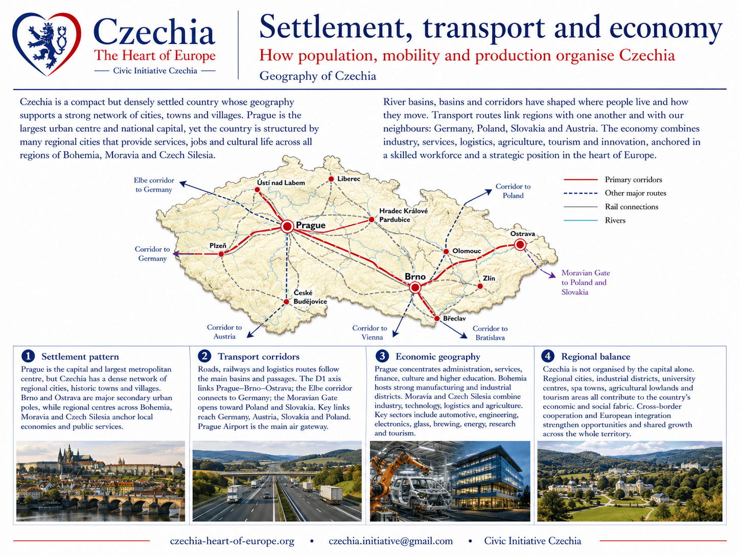
Human settlement in Czechia follows the logic of basins, rivers, passes, mining areas, fertile lowlands and historical centres. Prague, Brno, Ostrava, Plzeň, Olomouc, Liberec, Hradec Králové, Pardubice, České Budějovice, Zlín and other towns each occupy distinct geographic positions.
Transport and economic geography are also shaped by physical conditions. Railways, roads, industrial zones, logistics corridors, tourism regions and cross-border links use the same geographic framework: basins, valleys, lowlands, border passes and urban networks.
Urban networkCapital, regional cities, historical towns and industrial centres form a dense settlement structure.
Transport corridorsRoad and rail routes follow basins, valleys, passes and cross-border directions.
Industrial geographyManufacturing and mining regions are tied to resources, rivers, railways and urban labour.
Visitor geographyTourism follows cities, heritage sites, spa regions, mountains, forests, vineyards and river valleys.