Landscapes of Czechia hero image

About Czechia · Landscapes

Landscapes of Czechia

Czechia’s landscapes are shaped by mountain rims, fertile basins, forests, sandstone rock towns, karst and caves, vineyards, spa waters, protected nature, industrial heritage and living borderlands.

Mountains natural borders and highlands
Basins settlement and corridors
Protected nature national parks and PLAs
Culture spas, vineyards, rock towns

Landscape identity

Czechia is a mosaic of natural, cultural and transformed landscapes.

Czechia’s physical identity is not a single postcard. The country is framed by mountain arcs, opened by basins and corridors, crossed by river systems, covered by forests, carved by sandstone and limestone, marked by spa springs and vineyards, protected through national parks and shaped by centuries of industry, settlement and cultural memory.
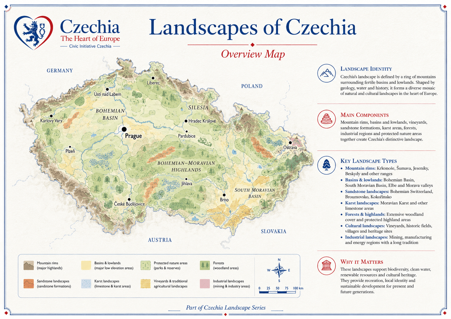
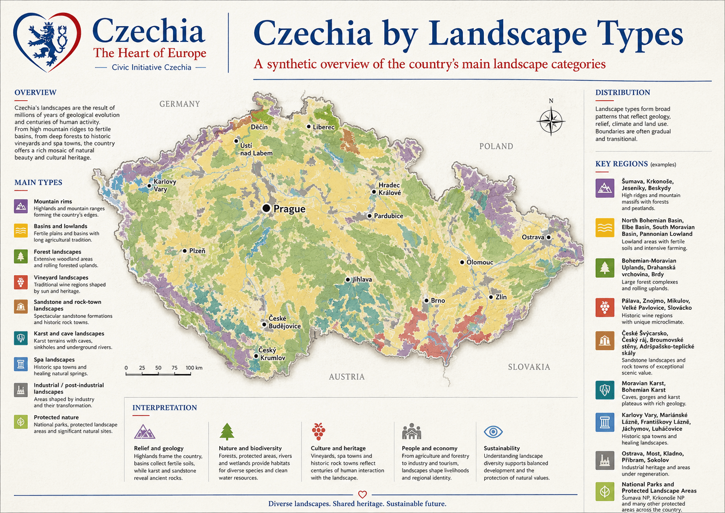
Overview map

The landscape map helps read Czechia beyond administrative borders.

Landscapes explain why regions feel different, why settlements grew in certain corridors, why some places became spa towns or vineyard areas, why forests and highlands matter, and why nature protection is inseparable from the country’s public identity.

Natural structure Mountain rims, basins, river valleys, forests, karst and sandstone formations.
Cultural landscape Vineyards, spa towns, historic fields, villages, castles, monasteries and traditions.
Transformed landscape Mining, industry, reclamation and post-industrial heritage.
landscapes of Czechia overview map

Landscape types

The main landscape categories overlap and transition gradually.

Czechia’s landscape types are not hard borders. Mountains descend into basins, forests meet agricultural land, sandstone areas carry castles and villages, karst landscapes hold caves and springs, and industrial regions are being reclaimed, reused and reinterpreted.

Relief and geology Mountains, basins, sandstone, limestone and cave systems.
Nature and biodiversity Forests, wetlands, protected areas, rivers and habitats.
People and economy Farming, industry, spa culture, tourism, heritage and innovation.
Czechia by landscape types map

Main landscape readings

Ten linked layers explain the country’s visual and territorial depth.

Each numbered layer below leads to its detailed section on the page.

Layer 01 · Relief Mountain rims Krkonoše, Šumava, Ore Mountains, Jeseníky, Beskids and other highlands frame the country and shape climate, rivers, forests and border identity. Layer 02 · Settlement Basins and corridors Lowlands, river valleys and mobility corridors explain settlement, agriculture, cities, industry, transport and internal cohesion. Layer 03 · Nature Forests Forests cover mountain regions, uplands and managed lowland mosaics, supporting biodiversity, water retention, timber traditions and recreation. Layer 04 · Conservation Protected nature National parks, protected landscape areas and smaller reserves preserve ecosystems, geological forms, forests, meadows, rivers and cultural landscapes. Layer 05 · Geology Karst and caves Limestone worlds create caves, sinkholes, underground rivers, springs, cliffs and scientific landscapes of high educational value. Layer 06 · Rock worlds Sandstone and rock towns Cliffs, towers, labyrinths, gorges and eroded sandstone landscapes give Czechia some of its most distinctive natural scenery. Layer 07 · Culture Vineyards South Moravian vineyards, wine villages, cellar lanes and estates form living cultural landscapes shaped by climate, soil and tradition. Layer 08 · Healing waters Spa landscapes Mineral springs, colonnades, parklands and spa towns connect water, architecture, health care, tourism and European cultural memory. Layer 09 · Transformation Industrial landscapes Mining basins, industrial cities, rail corridors and transformed heritage sites show how labour, energy, renewal and innovation shaped regions. Layer 10 · Frontiers Borderlands Mountain arcs and border zones connect Czechia with Germany, Poland, Austria and Slovakia through nature, routes, memory and cooperation.

Layer 01 · Mountain rims

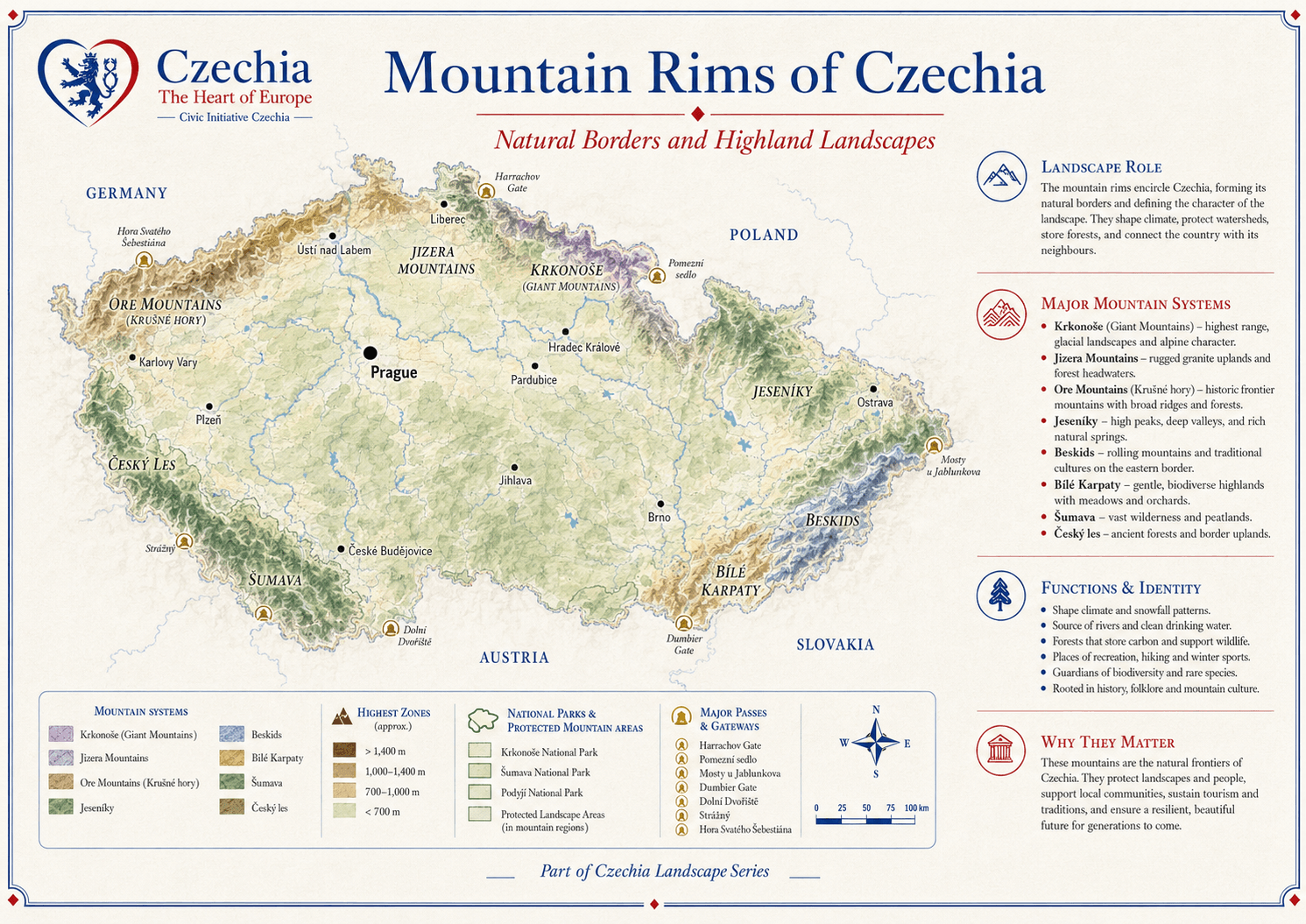
The mountains form Czechia’s natural borders and highland identity.

The mountain rims are guardians of climate, water, forests and regional identity. They include the Krkonoše, Jizera Mountains, Ore Mountains, Šumava, Český les, Jeseníky, Beskids and the White Carpathian context. They are routes, barriers, habitats, tourist destinations and historic frontiers at the same time.

Hydrology Mountain areas feed important river systems and protect headwaters.
Biodiversity Highlands contain forests, meadows, peatlands and rare habitats.
Culture Mountain regions carry folklore, border memory, tourism and outdoor traditions.
mountain rims of Czechia

Layer 02 · Basins, lowlands and corridors

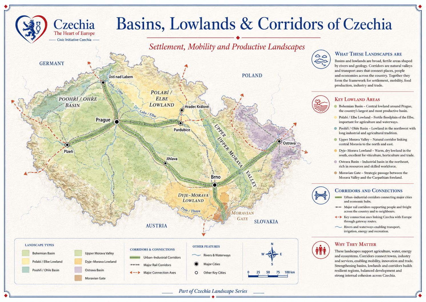
Lowlands and corridors explain settlement, mobility and production.

Basins and lowlands are broad fertile areas shaped by rivers and geology. Corridors are natural valleys and transport axes that connect places, people and economies. Together they form the framework for settlement, food production, industry, trade and internal cohesion.

Bohemian Basin Central lowland around Prague and the country’s largest internal settlement frame.
Elbe and Morava lowlands Fertile river landscapes with agriculture, transport and historic towns.
Moravian Gate Strategic passage between the Morava Valley and the Carpathian foreland.
basins lowlands and corridors of Czechia

Layer 03 · Forests

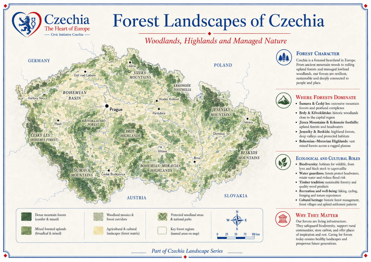
Forests are living infrastructure.

Czechia is one of Europe’s forested heartlands. Forests protect water, support wildlife, store carbon, shape recreation, sustain wood traditions and hold cultural memory. From Šumava to the Bohemian-Moravian Highlands and Beskids, forests link nature with settlement and public well-being.

Mountain forests Conifer and mixed forests dominate many highland regions.
Woodland mosaics Lowland and upland forests mix with fields, villages and protected areas.
Public role Forests support recreation, biodiversity, flood regulation and local identity.
forest landscapes of Czechia

Layer 04 · Protected nature

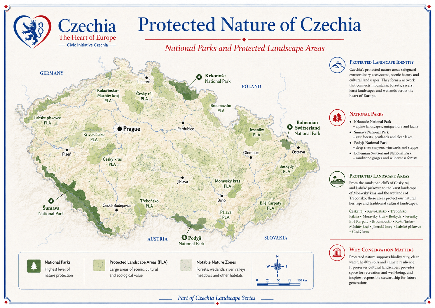
Protected areas safeguard ecosystems and cultural landscapes.

Czechia’s nature protection includes national parks, protected landscape areas, reserves, monuments, Natura 2000 sites and other protected zones. These areas conserve biodiversity, forests, meadows, wetlands, sandstone landscapes, karst areas, rivers and cultural landscapes shaped by responsible land use.

National parks Krkonoše, Šumava, Podyjí and České Švýcarsko.
Protected landscape areas Large scenic, cultural and ecological landscape units.
Public value Protection supports clean water, recreation, education, tourism and climate resilience.
protected nature of Czechia

Layer 05 · Karst and caves

Limestone landscapes reveal Czechia beneath the surface.

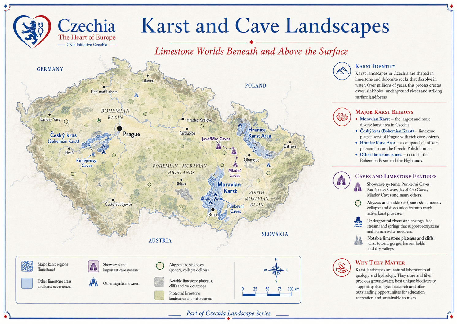
Karst landscapes form where limestone and dolomite rocks dissolve in water. Over time this creates caves, sinkholes, underground rivers, springs, cliffs and surface landforms. Moravian Karst is the largest and best-known karst area, while Bohemian Karst and other limestone zones add further geological depth.

Moravian Karst The largest and most diverse karst area in Czechia.
Cave systems Punkva Caves, Koněprusy Caves, Javoříčko Caves, Mladeč Caves and others.
Why it matters Karst stores and filters water, supports biodiversity and offers education and research value.
karst and cave landscapes of Czechia

Layer 06 · Sandstone and rock towns

Sandstone landscapes give Czechia sculptural scenery.

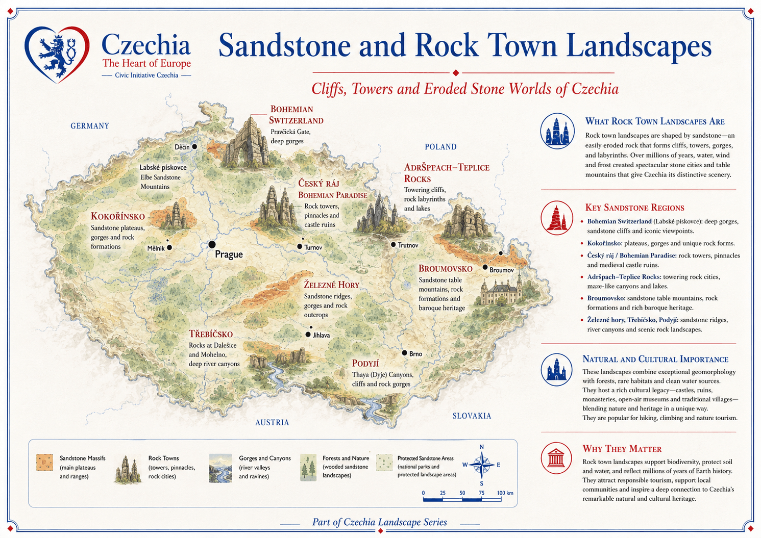
Sandstone rock towns are shaped by cliffs, towers, gorges, canyons, labyrinths and eroded stone worlds. Bohemian Switzerland, Český ráj, Adršpach-Teplice Rocks, Broumovsko, Kokořínsko and other areas combine geology, forests, castles, villages and exceptional scenic value.

Rock towns Towers, pinnacles, labyrinths and table formations.
Cultural layer Castles, ruins, monasteries, villages and hiking traditions.
Natural value Forests, clean water, habitats and geotourism.
sandstone and rock town landscapes of Czechia

Layer 07 · Vineyards and South Moravian landscapes

Wine country is a living cultural landscape.

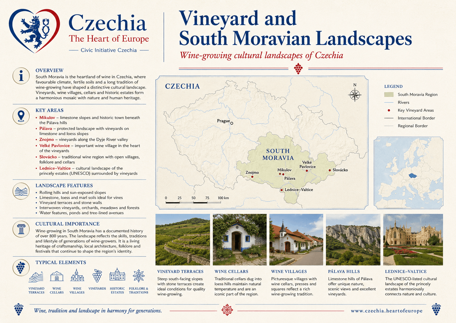
South Moravia is Czechia’s main wine-growing region, where climate, limestone slopes, loess soils, cellar lanes, village architecture, historic estates and folk traditions form a distinctive cultural landscape. Vineyards are agriculture, heritage, tourism and local identity at once.

Key places Mikulov, Pálava, Znojmo, Velké Pavlovice, Slovácko and Lednice-Valtice.
Landscape features Terraces, wine cellars, vineyard villages, orchards, meadows and limestone hills.
Cultural value Wine traditions, festivals, crafts, folklore and long-term rural continuity.
vineyard and South Moravian landscapes

Layer 08 · Spa landscapes and healing waters

Spa towns connect mineral springs, architecture and well-being.

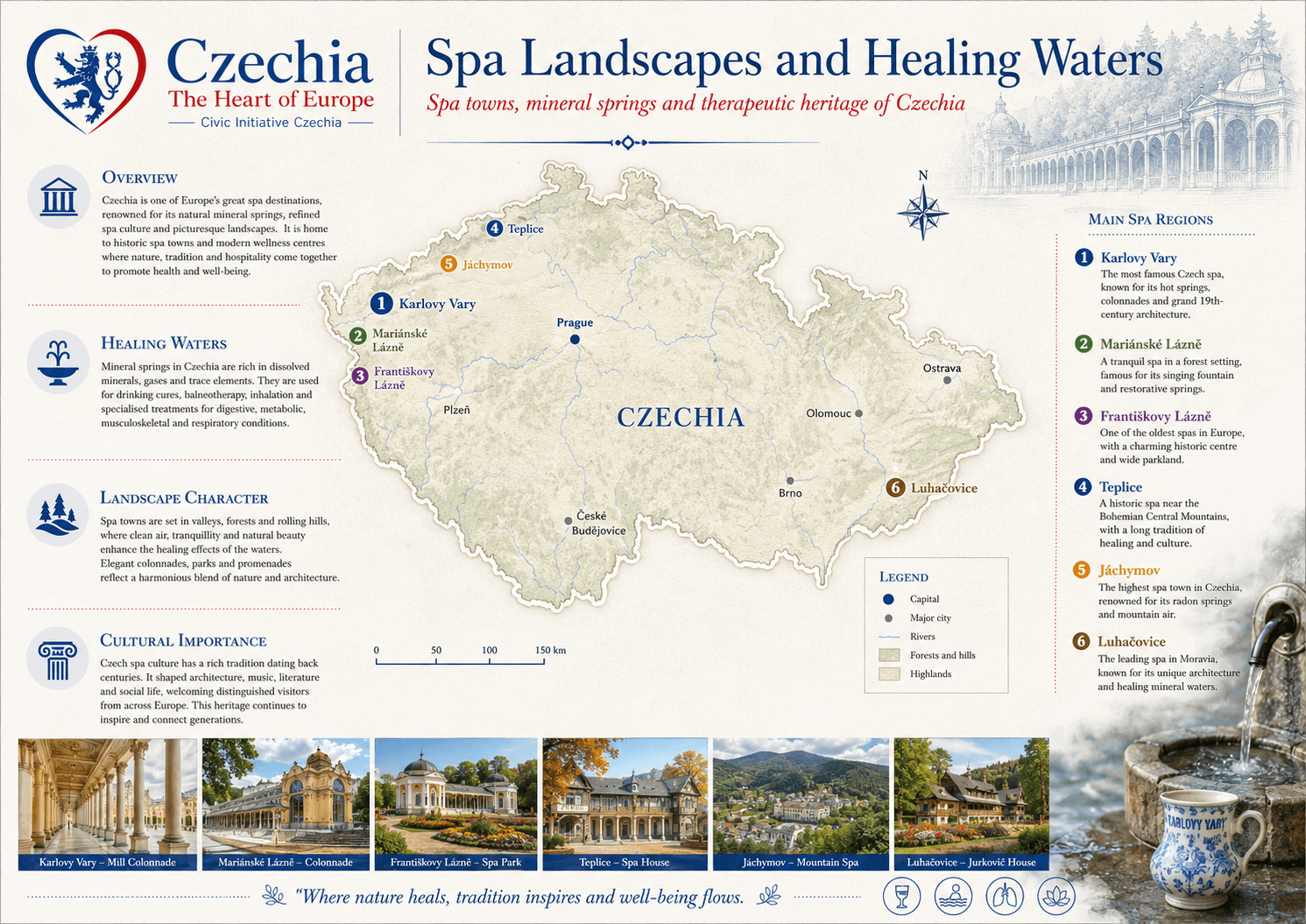
Czech spa landscapes combine natural mineral waters, refined urban space, colonnades, parks, promenades and health traditions. The most famous spa concentration is in West Bohemia, while places such as Luhačovice, Teplice, Třeboň and Poděbrady broaden the spa map across the country.

Western Bohemian spa triangle Karlovy Vary, Mariánské Lázně and Františkovy Lázně.
Architecture and parks Colonnades, parklands, promenades and historic spa houses.
Public identity Health, hospitality, tourism, heritage and European cultural memory.
spa landscapes and healing waters of Czechia

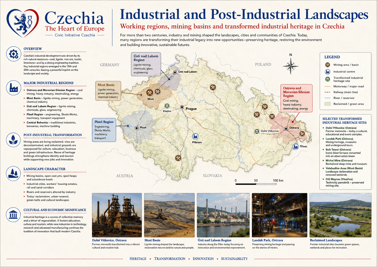
Layer 09 · Industrial and post-industrial landscapes

Industry is part of Czechia’s landscape memory.

Mining, metallurgy, engineering, glass, railways and energy transformed many Czech landscapes. Today, former industrial areas are being reclaimed, reused and interpreted as cultural heritage, education spaces, innovation districts, green areas and tourism sites.

Major regions Ostrava and Moravian-Silesian Region, Most Basin, Ústí nad Labem Region, Plzeň and Central Bohemia.
Transformation Reclamation, reuse, museums, cultural venues, brownfield renewal and new economies.
Why it matters Industrial heritage preserves labour memory while supporting innovation and regional renewal.
industrial and post-industrial landscapes of Czechia

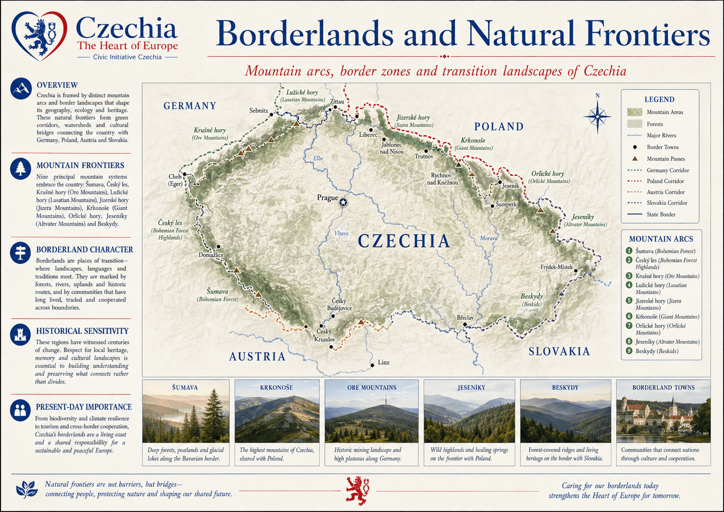
Layer 10 · Borderlands and natural frontiers

Natural frontiers are bridges as much as borders.

Czechia is framed by mountain arcs and border landscapes that shape geography, ecology and heritage. Borderlands connect the country with Germany, Poland, Austria and Slovakia through forests, passes, towns, rivers, languages, trade, tourism and shared environmental responsibility.

Mountain frontiers Šumava, Český les, Krušné hory, Lužické hory, Jizera Mountains, Krkonoše, Orlické hory, Jeseníky and Beskydy.
Borderland character Transition zones where landscapes, languages, routes and communities meet.
Present-day importance Biodiversity, climate resilience, tourism and cross-border cooperation.
borderlands and natural frontiers of Czechia

Timeline

Landscape is a long bond between geology, water, nature, and people.

  1. Deep time Hundreds of millions of years
    Geological forces over millions of years shaped Czechia’s mountains, basins, sandstone plateaus, limestone belts, and mineral wealth — the physical stage on which all later landscapes developed.
  2. Settlement Neolithic to Medieval period (c. 5000 BCE – 1500 CE)
    Rivers, fertile soils, lowlands, and natural passes determined where people built towns, opened routes, farmed land, and exchanged goods, anchoring human geography to natural structure.
  3. Industrial age 18th century – 20th century
    Mining, heavy industry, railways, and energy infrastructure reshaped entire regions, leaving visible patterns of pits, factories, dams, and worker settlements that still define many landscapes.
  4. Protection 20th century – today
    National parks, protected landscape areas, and conservation systems preserve biodiversity, traditional land use, and cultural scenery while balancing tourism, forestry, and local livelihoods.
  5. Today 21st century
    Czechia’s landscapes now support tourism, regional identity, outdoor education, climate adaptation, sustainable development, and overall quality of life.