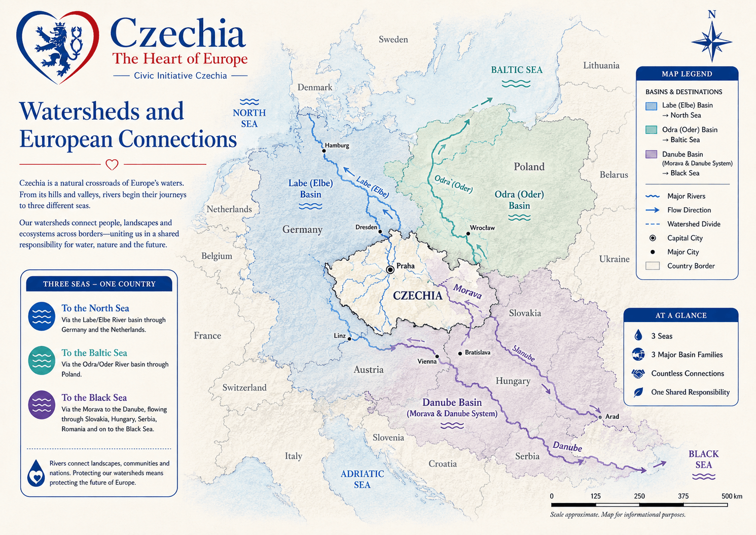
Czechia is a Central European watershed country. Its rivers begin in
highlands, cross historical lands and regions, and leave the country
toward the North Sea, Baltic Sea and Black Sea.
Czechia is landlocked, but its waters are strongly European. Rivers
rising in Czech highlands flow toward three different sea basins:
the Elbe (Labe) system reaches the North Sea, the Odra (Oder) reaches
the Baltic Sea, and the Morava-Danube system reaches the Black Sea.
This makes water one of the clearest ways to understand Czechia’s
geography, regions, historical lands, settlements and cross-border
responsibilities.
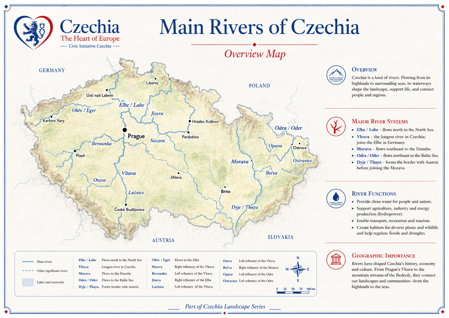
Overview map
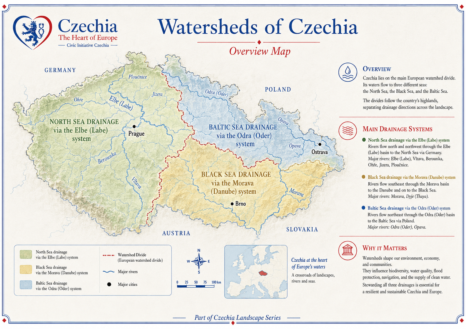
The watershed map reveals Czechia as a natural crossroads.
Czechia lies on the main European watershed divide. Its highlands
separate drainage directions and send water toward the North Sea,
Baltic Sea and Black Sea. Watersheds influence biodiversity, water
quality, flood protection, navigation, settlement and the supply
of clean water.
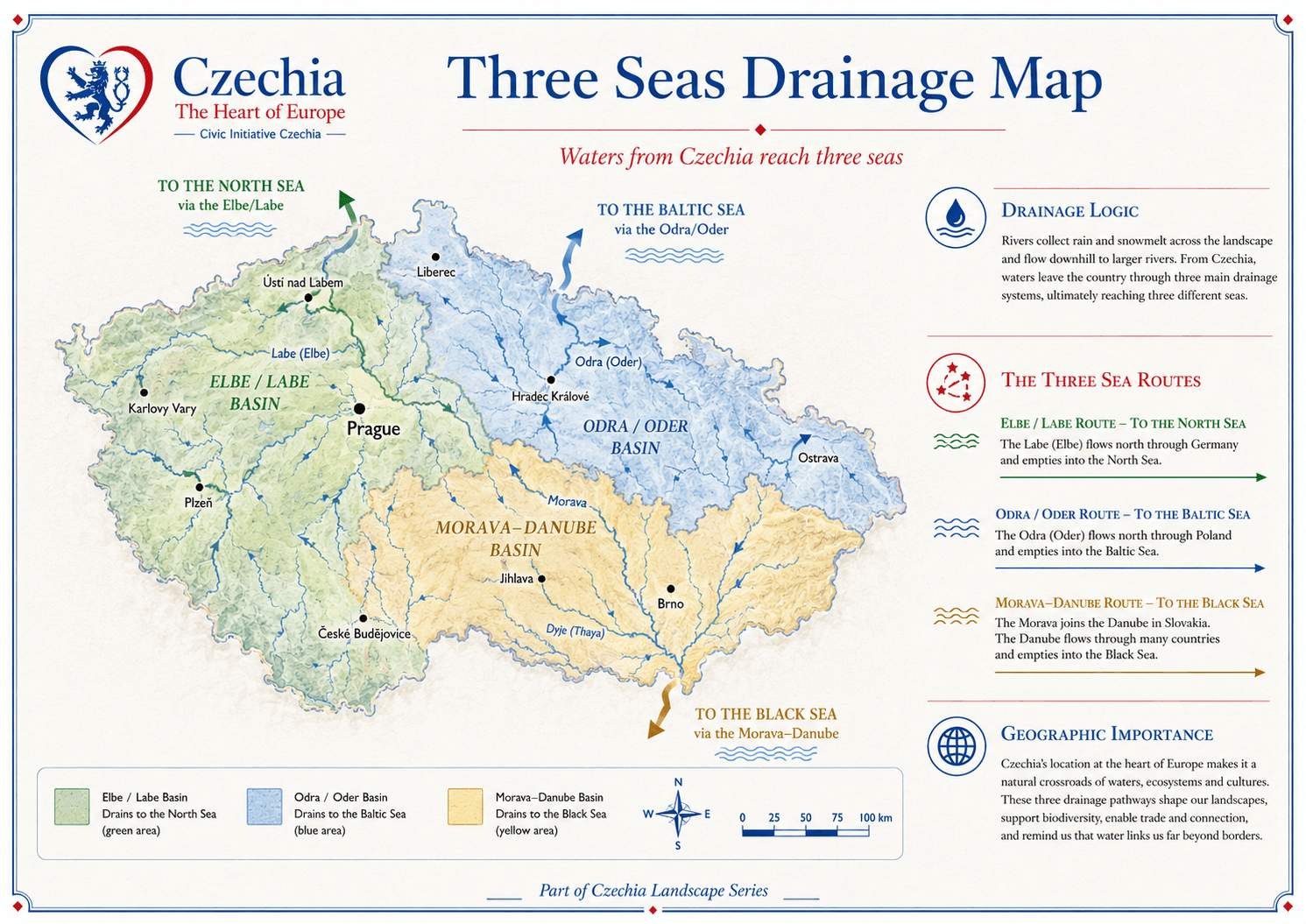
Rain and snowmelt collected in Czechia leave the country through
three major directions. The Elbe (Labe) flows north and northwest.
The Odra (Oder) flows northeast. The Morava joins the Danube system
and turns southeast. These routes make Czechia a water crossroads
of Central Europe.
Elbe (Labe) routeTo the North Sea through Germany.
Odra (Oder) routeTo the Baltic Sea through Poland.
Morava-Danube routeTo the Black Sea through the Danube system.
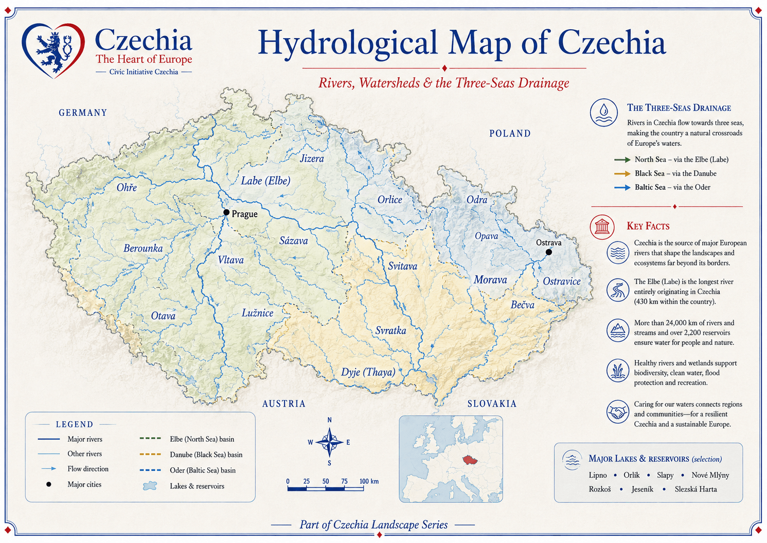
The river network gives Czechia its water skeleton.
The hydrological map shows how many rivers and streams flow from
highlands into larger basins. The Vltava and Elbe (Labe) dominate
Bohemia, the Morava structures the eastern part of the country,
and the Odra (Oder) gives the northeast its Baltic connection.
River densityRivers and streams connect highlands, basins, towns and reservoirs.
DividesWatershed divides separate water flowing to different seas.
Public valueHealthy rivers support water supply, biodiversity, flood protection and recreation.
Czechia’s main rivers provide water, support agriculture and
industry, create habitats, connect towns and shape cultural
identity. From Prague’s Vltava to the Morava corridor and the
Odra (Oder) basin, rivers are practical infrastructure and public
memory at the same time.
VltavaThe longest river within Czechia.
Elbe (Labe)A major Central European river flowing toward Germany and the North Sea.
Morava and Odra (Oder)Eastern and northeastern systems linking Czechia to the Danube and Baltic worlds.
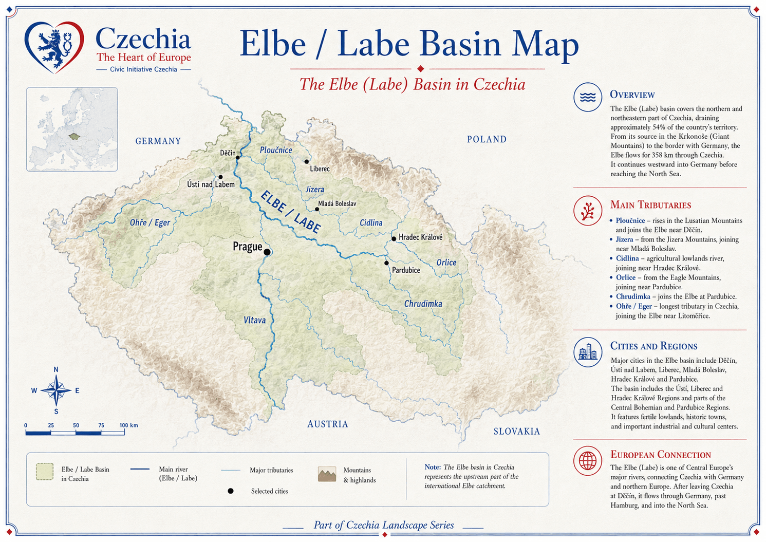
The Elbe (Labe) basin carries Czech waters toward the North Sea.
The Elbe (Labe) drains the northern and northeastern part of Czechia
and receives the Vltava at Mělník. It then continues into Germany,
linking Czechia with one of Europe’s major river corridors and the
North Sea.
Major tributariesVltava, Ohře (Eger), Jizera, Ploučnice, Orlice, Cidlina and Chrudimka.
Regional citiesDěčín, Ústí nad Labem, Hradec Králové, Pardubice and others.
European connectionThe river continues through Germany toward Hamburg and the North Sea.
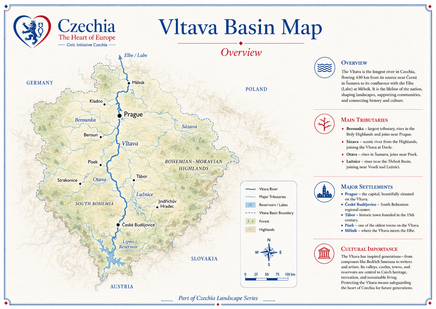
The Vltava rises in Šumava, flows through southern and central
Bohemia, passes Prague and joins the Elbe (Labe) at Mělník. It is
central to landscape, culture, settlement, water management and
the public image of the country.
Source areaŠumava and southern Bohemia.
Major placesČeské Budějovice, Tábor, Prague and Mělník.
Reservoir systemLipno, Orlík, Slapy and other reservoirs support water management, energy, recreation and flood regulation.
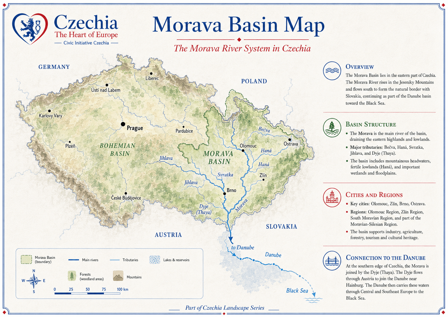
The Morava rises in the north of Moravia and flows south, forming
part of the border with Slovakia before joining the Danube system.
Its basin supports fertile lowlands, agriculture, cities, wetlands,
transport corridors and cultural landscapes.
Major tributariesBečva, Haná, Svratka, Jihlava, Dyje (Thaya) and others.
Major citiesOlomouc, Zlín, Brno, Ostrava and other regional centres in the wider basin context.
Danube linkThrough the Danube system, waters continue toward the Black Sea.
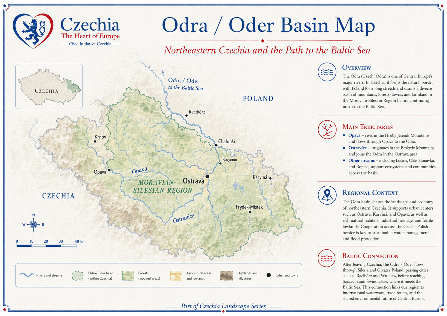
The Odra (Oder) gives northeastern Czechia its Baltic connection.
The Odra (Oder) basin drains northeastern Czechia and continues
north through Poland toward the Baltic Sea. It is important for
Ostrava, Czech Silesia, forested uplands, industrial heritage,
flood protection and Czech-Polish water cooperation.
Main tributariesOpava, Ostravice and other streams of the northeastern basin.
Regional contextOstrava, Opava, Karviná and Frýdek-Místek.
International routeThrough Silesia and Poland toward the Baltic Sea.
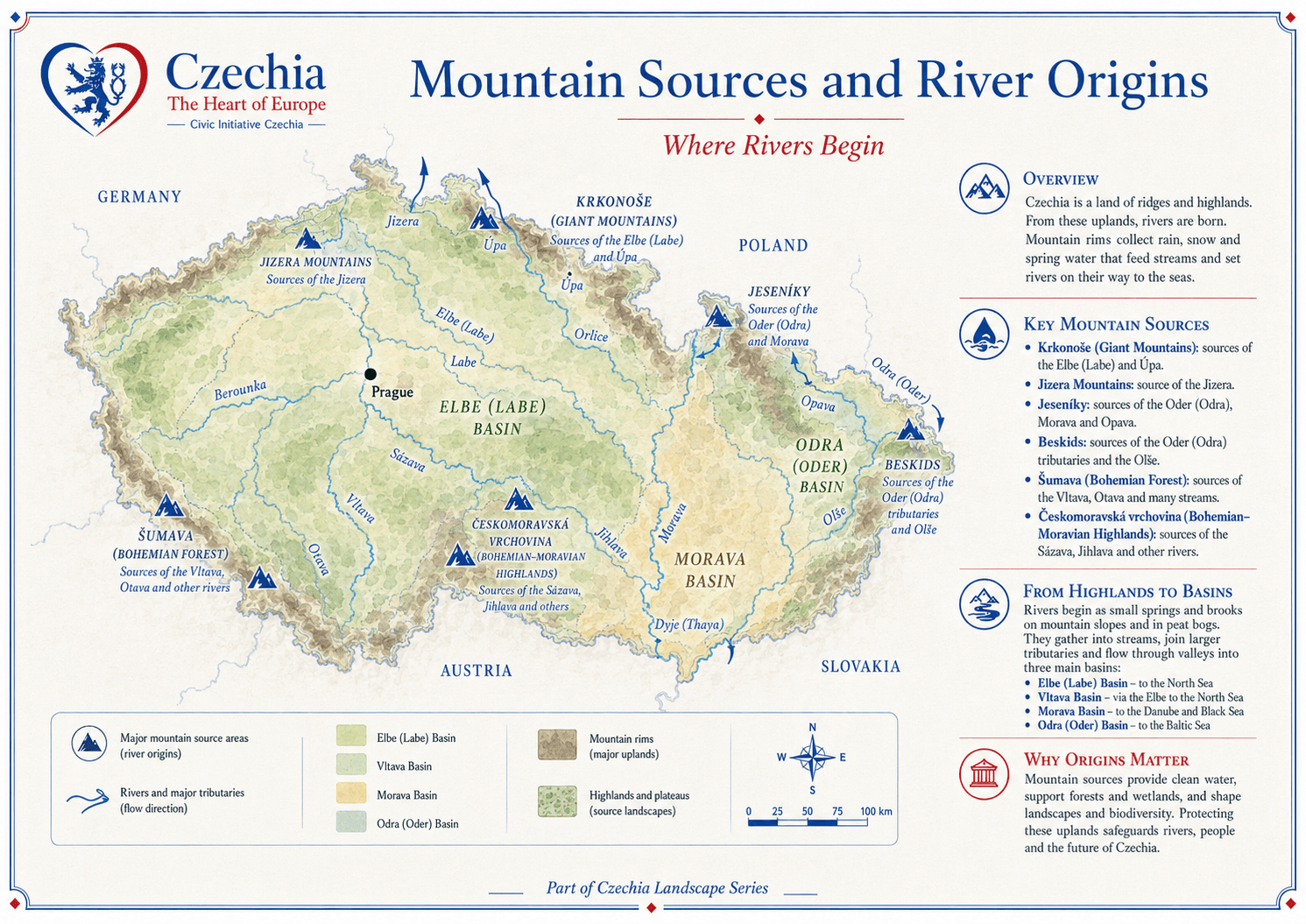
Rivers begin in ridges, highlands, springs and peatlands.
Czechia’s mountain sources are vital because the country has no
sea coast and depends on water collected in its highlands. Šumava,
Krkonoše, Jizera Mountains, Jeseníky, Beskids and the Bohemian-
Moravian Highlands feed rivers that later serve towns, farms,
industry, ecosystems and neighbouring countries.
Headwater beltsHighlands collect rainfall, snowmelt and springs.
Upland protectionForests and peatlands support water retention and quality.
Future valueProtecting source landscapes safeguards rivers and people downstream.
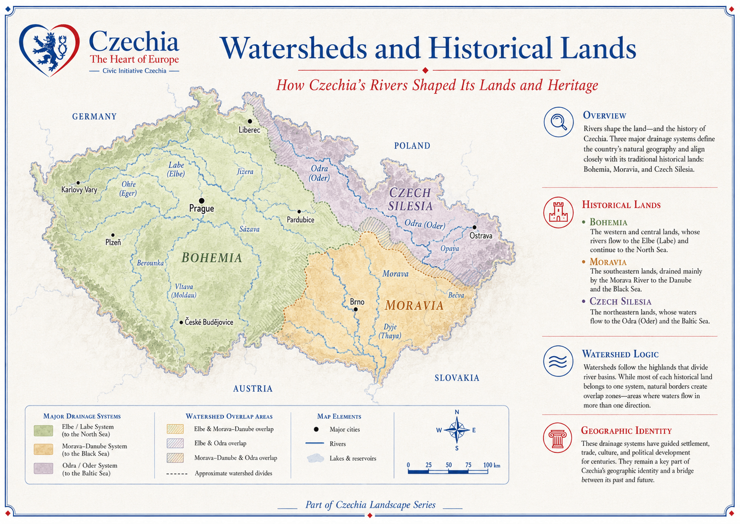
Water helps explain Bohemia, Moravia and Czech Silesia.
Rivers align closely with the historical lands. Bohemia is strongly
tied to the Vltava and Elbe (Labe) systems. Moravia is linked to
the Morava and Danube system. Czech Silesia is connected with
the Odra (Oder) basin. Overlap zones show that water often crosses
cultural and administrative boundaries.
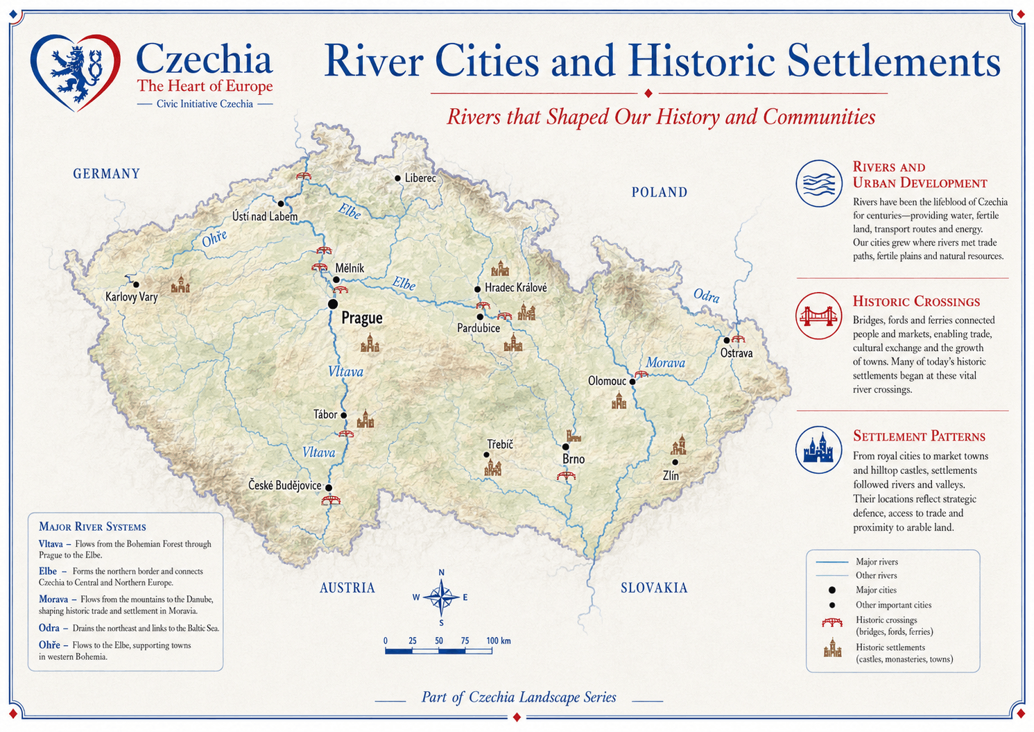
Historic settlements grew where rivers offered water, fertile land,
crossings, trade routes, defence and energy. Prague on the Vltava,
towns along the Elbe (Labe), Morava and Odra (Oder) systems, and many
smaller crossings show how water shaped urban development.
CrossingsBridges, fords and ferries supported markets, movement and exchange.
SettlementsRoyal towns, market towns, hilltop castles and river valleys grew together.
MemoryRivers remain part of local identity, recreation and public space.
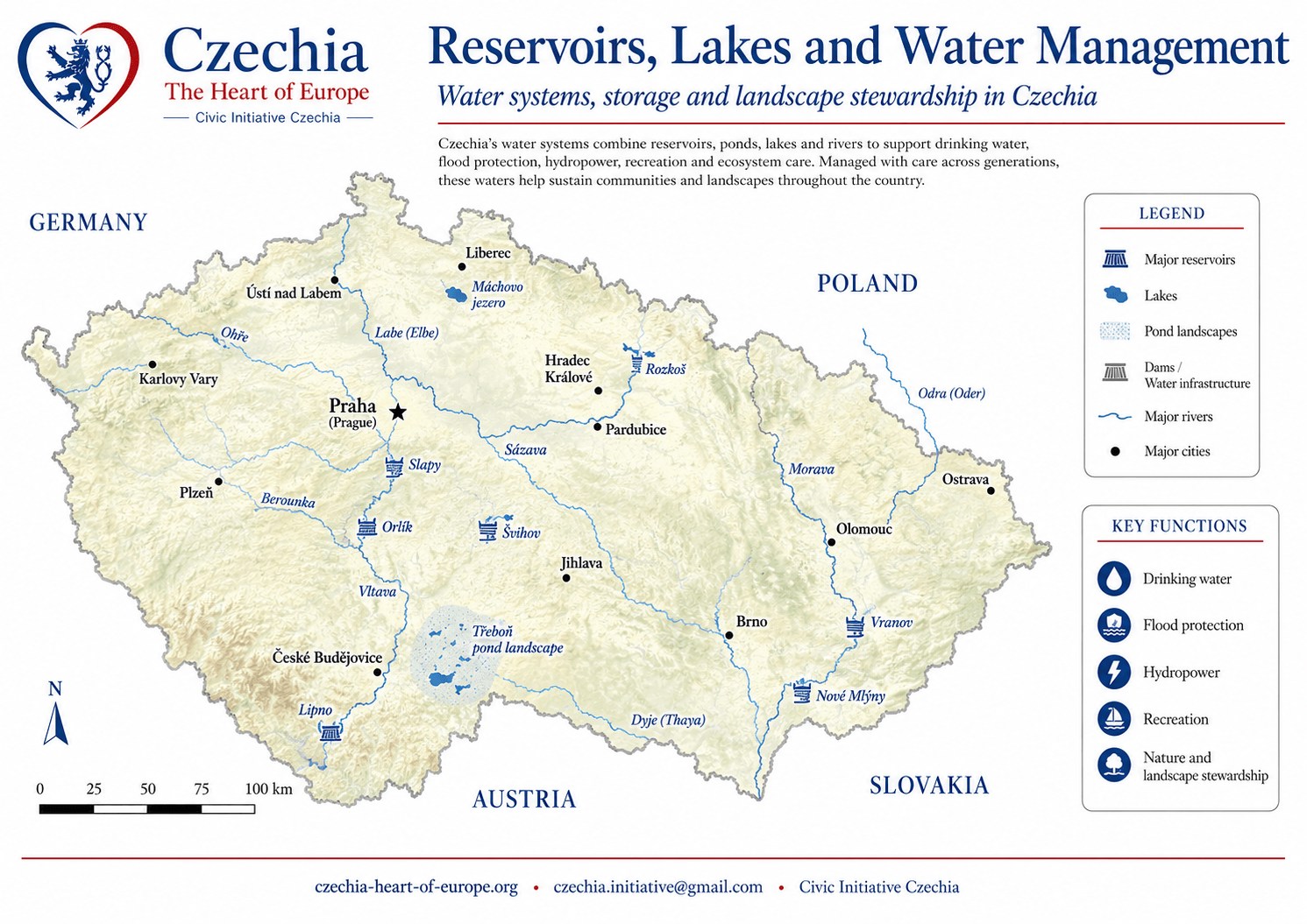
Water storage supports people, energy, safety and nature.
Reservoirs, ponds, lakes and water infrastructure help Czechia
store water, supply drinking water, generate hydropower, reduce
flood risks, support recreation and sustain ecosystems. Water
management connects landscape stewardship with everyday public life.
Major reservoirsLipno, Orlík, Slapy, Švihov, Vranov, Nové Mlýny and others.
FunctionsDrinking water, flood protection, hydropower, recreation and biodiversity.
Public valueWater infrastructure supports both resilience and quality of life.
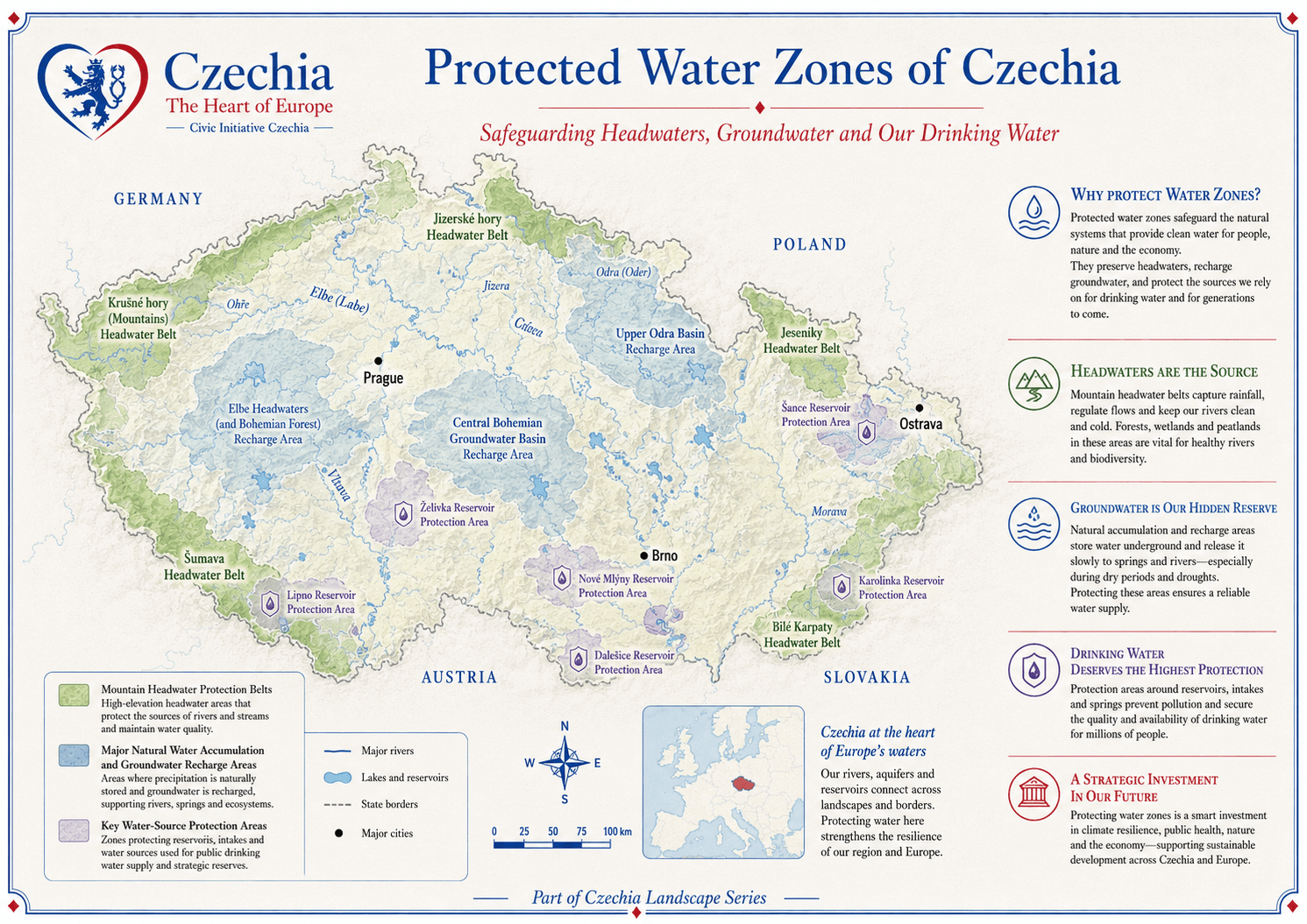
Water-source protection is a strategic public responsibility.
Protected water zones safeguard headwaters, groundwater recharge
areas, reservoirs, intakes and springs. They help protect clean
drinking water, reduce pollution, preserve ecosystem functions and
maintain reliable water supply during droughts and climate stress.
HeadwatersMountain belts and forested uplands capture and regulate water.
GroundwaterRecharge areas store and release water gradually.
Drinking waterReservoir protection zones secure supply for people and the economy.
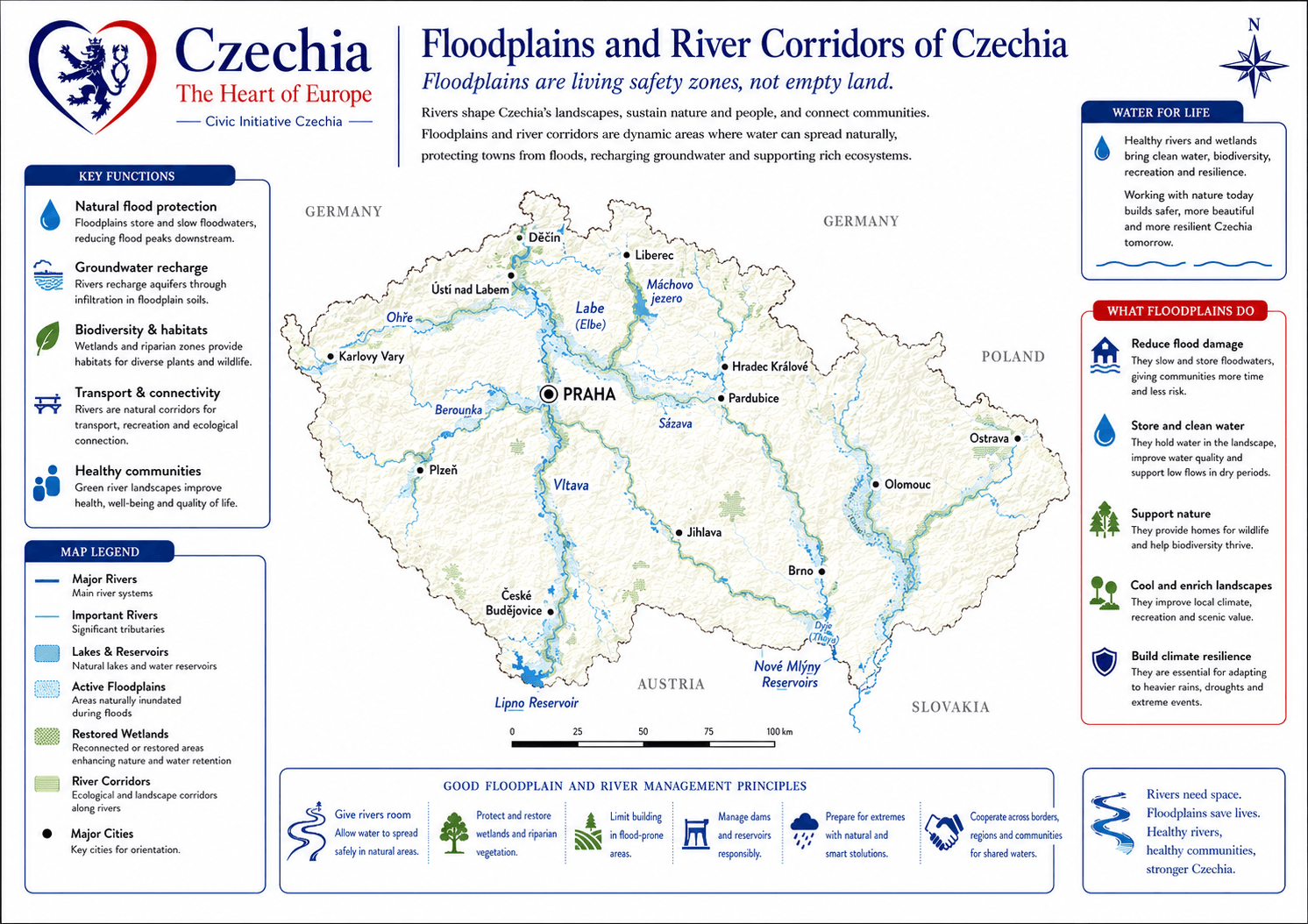
Floodplains are living safety zones, not empty land.
Floodplains store water, slow floods, support wetlands, protect
towns and create habitats. They are important for climate adaptation,
soil moisture, biodiversity, agriculture and responsible spatial
planning. Reading Czechia through floodplains helps connect water
management with land use and public safety.
Natural retentionFloodplains slow runoff and help reduce flood peaks.
Ecological valueWetlands, meadows and riparian habitats support biodiversity.
Planning valueFlood-risk areas require careful settlement, infrastructure and landscape planning.
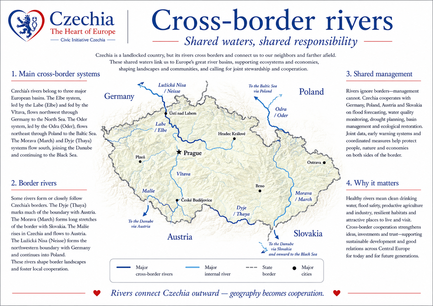
Czechia’s rivers connect the country with Germany, Poland, Austria
and Slovakia. Cross-border cooperation is essential for floods,
droughts, water quality, navigation, ecosystems and emergency
response. Rivers are borders in some places, but they are also
corridors of cooperation.
West and northwestLabe (Elbe), Ohře (Eger) and other systems link Czechia with Germany.
NortheastOdra (Oder) and tributaries connect with Poland.
South and southeastVltava (Moldau), Dyje (Thaya) and Morava connect with Austria and Slovakia.
Watersheds connect Czechia to Europe beyond its borders.
Czechia’s watersheds show the country as a natural crossroads in
Europe. From the Elbe (Labe) basin to the North Sea, the Odra (Oder)
basin to the Baltic Sea and the Morava-Danube system to the Black
Sea, rivers connect landscapes, ecosystems, cities and countries.
North SeaElbe (Labe) basin through Germany and the Netherlands.
Baltic SeaOdra (Oder) basin through Poland.
Black SeaMorava-Danube system through Central and Southeast Europe.
Water links geology, settlement, management and future resilience.
Deep timeHundreds of millions of years
Relief and geology create mountain source areas, basins, groundwater bodies and river corridors.
SettlementNeolithic to Medieval period (c. 5000 BCE–1500 CE)
Towns, crossings, mills, farms and trade routes develop along rivers and fertile floodplains.
Modern management19th century–21st century
Reservoirs, river-basin administration, water-supply systems and flood protection become part of public infrastructure.
Protection20th century–today
Headwaters, groundwater recharge areas, protected water zones and natural retention become central to water security.
Today21st century
Watershed literacy helps Czechia plan for climate resilience, cooperation, public safety and sustainable regional development.
Continue exploring
Read the neighbouring layers of the country profile.
These official and primary sources support the page’s explanation of
Czechia’s water systems, hydrology, water management, river basins and
water protection.